Carnic Alps
| Carnic Alps | |
|---|---|
| Alps Cjargnelis (Friulian) Karnische Alpen (German) Alpi Carniche (Italian) Karnijske Alpe (Slovene) | |
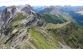
 View from Pfannspitze along the main ridge to the east. | |
| Highest point | |
| Peak | Coglians |
| Elevation | 2,782 m (9,127 ft) |
| Coordinates | 46°36′N 12°53′E / 46.600°N 12.883°E |
| Geography | |
 | |
| Countries | |
| Länder, Regioni | |
| Range coordinates | 46°30′N 13°00′E / 46.500°N 13.000°E |
| Parent range | Southern Limestone Alps |
| Geology | |
| Orogeny | Alpine orogeny |
The Carnic Alps (Italian: Alpi Carniche; German: Karnische Alpen; Slovene: Karnijske Alpe; Friulian: Alps Cjargnelis) are a range of the Southern Limestone Alps in Austria and northeastern Italy. They are within Austrian East Tyrol and Carinthia, and Italian Friuli (Province of Udine) and marginally in Veneto.
Etymology
[edit]They are named after the Roman province of Carnia, which probably has a Celtic origin.
The mountains gave their name to the stage on the geologic time scale known as Carnian, an age in the Triassic Period.
Geography
[edit]They extend from east to west for about 100 km (62 mi) between the Gail River, a tributary of the Drava and the Tagliamento, forming the border between Austria and Italy.
Alpine Club classification
[edit]The Carnic Alps are divided into two distinct areas:
|
In the Carnic Alps is the southernmost glacier in Austria, the Eiskar, nestling in the Kellerwand massif.
Notable peaks
[edit]
Among the most important mountains of the range are:
- Coglians / Hohe Warte (2,782 m)
- Kellerspitzen (2,774 m)
- Monte Peralba / Hochweißstein (2,694 m)
- Monte Cavallino / Große Kinigat (2,689 m)
- Rosskopf (2,603 m)
- Monte Terza Grande (2,586 m)
- Monte Bìvera (2,474 m)
- Creta Forata (2,462 m)
- Helm (2,434 m)
- Cresta di Enghe (2,414 m)
- Monte Ferro (2,348 m)
- Gailtaler Polinik (2,332 m)
- Trogkofel (2,280 m)
- Monte Sernio (2,187 m)
Mountain passes
[edit]
The chief passes of the Carnic Alps are:
- Plöcken Pass (Tolmezzo to Kötschach-Mauthen), road (1,360 m)
- Naßfeld Pass (Pontebba to Hermagor-Pressegger See), road (1,552 m)
- Öfnerjoch (Forni Avoltri to Sankt Lorenzen im Lesachtal), footpath (2,301 m)
- Wolayer Pass (same to Kötschach-Mauthen), footpath (1,922 m)
